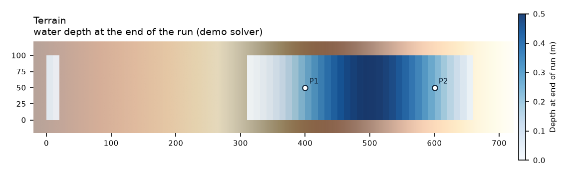
Gaps are times when the cell at that point is dry.
What happens
Rising water spills over a 10.25 m ridge into a hollow, then falls away again. The trapped pond must end level with the ridge crest.
Why it matters
Floodplains are full of hollows that fill and stay wet. Models must not lose or invent water as it is trapped.
A good model must
leave the pond at the crest level within 2 cm
reach the right peak level
Exact answer and models
Water level at gauge P1 (400 m, 50 m)
The pond must settle at the level of the sill once the boundary falls (dashed).
Point at the chart to read every model's value; click a name to hide or show it.
How models did
In rank order: by each model's percent difference from the right answer, the largest over the test's accuracy checks (lower is better; results within 10 % of each other share a rank). Mass error, timing and NSE are shown beside it, not folded in. Each model runs the same inputs. Compare them in the results viewer (depth maps and animation) →
The test itself (inputs, exact answer, checks): A2C-EA1.zip. Check the score card with benchmark1d2d verify-card: its signature by the suite's public development key shows the card has not changed since it was written, not who wrote it.
Demo 2D
Worked example that ships with the suite: first-order finite volume
#2 0.44 % off
Run time, finest grid: 14.3 s· AMD EPYC 9V74 80-Core Processor, 2 cores, 15.6 GB, Linux 6.17.0-1022-azure (GitHub Actions (github-hosted, ubuntu24))
The model files for this run will be published with its next run.
The test itself (inputs, exact answer, checks): A2C-EA1.zip. Check the score card with benchmark1d2d verify-card: its signature by the suite's public development key shows the card has not changed since it was written, not who wrote it.
TELEMAC-2D
openTELEMAC-2D 9.1.1, run with its default finite-volume settings
#3 0.56 % off
Run time, finest grid: 59.5 s· AMD EPYC 7763 64-Core Processor, 2 cores, 15.6 GB, Linux 6.17.0-1022-azure (GitHub Actions (github-hosted, ubuntu24))
Settings: telemac2d (Selafin, nodes at the grid's cell centres)
The test itself (inputs, exact answer, checks): A2C-EA1.zip. Check the score card with benchmark1d2d verify-card: its signature by the suite's public development key shows the card has not changed since it was written, not who wrote it.
The test itself (inputs, exact answer, checks): A2C-EA1.zip. Check the score card with benchmark1d2d verify-card: its signature by the suite's public development key shows the card has not changed since it was written, not who wrote it.
ANUGA
ANUGA 4.0.1 (Geoscience Australia / ANU), default settings on a triangular mesh
#5= 1.9 % off
Run time, finest grid: 1.7 min· AMD EPYC 7763 64-Core Processor, 2 cores, 15.6 GB, Linux 6.17.0-1022-azure (GitHub Actions (github-hosted, ubuntu24))
Settings: anuga (rectangular_cross mesh, defaults, sampled at cell centres)
The model files for this run will be published with its next run.
ANUGA builds its mesh and boundaries in Python: the script is the model.
The test itself (inputs, exact answer, checks): A2C-EA1.zip. Check the score card with benchmark1d2d verify-card: its signature by the suite's public development key shows the card has not changed since it was written, not who wrote it.
LISFLOOD-FP ACC
LISFLOOD-FP 8.3, the local-inertia solver it is best known for; it leaves out the advection term
#5= 2.1 % off
Run time, finest grid: 3.4 s· AMD EPYC 7763 64-Core Processor, 2 cores, 15.6 GB, Linux 6.17.0-1022-azure (GitHub Actions (github-hosted, ubuntu24))
The pond settles 5 mm above the sill. The stored volume is 2.7 % above the figure integrated on the EA's 2 m DEM; that check does not gate, because a 10 m grid samples the ground differently.
The test itself (inputs, exact answer, checks): A2C-EA1.zip. Check the score card with benchmark1d2d verify-card: its signature by the suite's public development key shows the card has not changed since it was written, not who wrote it.
HEC-RAS 7.0
HEC-RAS 7.0.1 2D with its Eulerian shallow-water option (SWE-EM), which HEC recommends for dam breaks
#7= 5.1 % off
Run time, finest grid: 23.5 s· AMD EPYC 7763 64-Core Processor, 2 cores, 16 GB, Windows 2025Server (GitHub Actions (github-hosted, win25-vs2026))
The test itself (inputs, exact answer, checks): A2C-EA1.zip. Check the score card with benchmark1d2d verify-card: its signature by the suite's public development key shows the card has not changed since it was written, not who wrote it.
HEC-RAS 6.6
HEC-RAS 6.6 2D with its Eulerian shallow-water option (SWE-EM), the release before 7.0
#7= 5.1 % off
Run time, finest grid: 26.0 s· AMD EPYC 7763 64-Core Processor, 2 cores, 16 GB, Windows 2025Server (GitHub Actions (github-hosted, win25-vs2026))
The test itself (inputs, exact answer, checks): A2C-EA1.zip. Check the score card with benchmark1d2d verify-card: its signature by the suite's public development key shows the card has not changed since it was written, not who wrote it.
HEC-RAS 7.0
HEC-RAS 7.0.1 (US Army Corps of Engineers), built and run headless with its default settings; in 2D, its default full shallow-water option (SWE-ELM)
#7= 5.1 % off
Run time, finest grid: 19.3 s· AMD EPYC 9V74 80-Core Processor, 2 cores, 16 GB, Windows 2025Server (GitHub Actions (github-hosted, win25-vs2026))
The test itself (inputs, exact answer, checks): A2C-EA1.zip. Check the score card with benchmark1d2d verify-card: its signature by the suite's public development key shows the card has not changed since it was written, not who wrote it.
HEC-RAS 6.6
HEC-RAS 6.6, the release before 7.0, run the same way (1D, and 2D with its default SWE-ELM): kept so a change between versions shows
#7= 5.1 % off
Run time, finest grid: 37.7 s· AMD EPYC 7763 64-Core Processor, 2 cores, 16 GB, Windows 2025Server (GitHub Actions (github-hosted, win25-vs2026))
The test itself (inputs, exact answer, checks): A2C-EA1.zip. Check the score card with benchmark1d2d verify-card: its signature by the suite's public development key shows the card has not changed since it was written, not who wrote it.
Not run yet: GeoClaw, TUFLOW, MIKE 21, Iber, BASEMENT, Delft3D FM
Technical details for reviewers Checks, reference, inputs, sources
Checks and why each limit was chosen
Check
Difference measured as a percentage of
Latest
Difference
Why this check
final_level_p1
expected_state_error of h · in the score
of the 0.25 m pond depth at P1
–
A solver that conserves mass and handles the sill must leave the pond at the crest level; 2 cm allows for slow drainage over the sill by t = 20 h.
final_level_p2
expected_state_error of h · in the score
of the 0.25 m pond depth at P2
–
Same pond as P1, so it must settle at the same 10.25 m crest level; a second point catches a solver that leaves the pond tilted or partly drained.
peak_level
expected_state_error of h · in the score
of the 0.35 m plateau depth
–
Hydrostatic plateau level during the 10 h hold.
final_volume
expected_state_error of volume · reported, not counted
already a percentage
–
Informational: depends on how the solver samples the 2 m DEM onto its own grid.
Reference
No exact or measured answer exists. The test is scored on states that follow from the inputs alone; published package results are context only.
Expected state
Value
Why it must hold
pond_final_level_p1
h+z at P1
10.25 m
Specification §2: after the boundary falls the pond becomes horizontal at the sill elevation, 10.25 m (sill crest at x = 300 m in the DEM).
pond_final_level_p2
h+z at P2
10.25 m
As P1; both points lie in the same pond.
peak_level
h+z at P1,P2
10.35 m
Boundary holds 10.35 m for 10 h (60–660 min), long enough for the whole domain to become horizontal (specification §2).
final_stored_volume
volume
9,954 m3
Pond below 10.25 m (9887.3 m³) plus water below 9.7 m elsewhere (66.9 m³), integrated on the 2 m EA DEM. Solvers on a 10 m grid sample the DEM differently, so this check does not gate.
More figures
P1
P2
Gaps are times when the cell at that point is dry.
Promotion checklist
Only frozen tests have fixed inputs and answers. This list is computed from the manifest and the published score cards; the rules are in the method.
✓Data licence verifiedfor candidateOGL-UK-3.0
✓All inputs availablefor candidateall committed or fetched by SHA-256
✓Reference (truth) availablefor candidateobjective expected states
✓Every tolerance justifiedfor candidateeach gating criterion has a rationale
✓A published run passesfor frozen10 passing score card(s)
✓Order of accuracy shownfor frozennot a verification case
Inputs come from the GOV.UK 'Benchmarking model data' archive, published under the Open Government Licence v3.0 (the page licence; the archive carries no other terms). Attribution: Environment Agency, SC120002 (2013), test specifications May 2010.